The Almshouses of Balls Pond Road
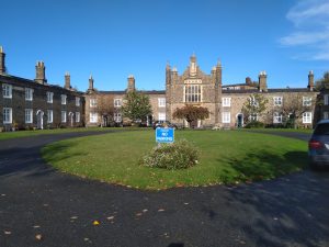
At Islington borough’s eastern edge, on the north side of Balls Pond Road, beyond the traffic bustle and behind railings, these old two-story buildings surround a tranquil green courtyard. They are … Read more
This map is taken from Charles Booth’s Poverty Survey in around 1898. Booth walked the streets of late Victorian London, accompanied by a local policeman, then produced maps and notebooks … Read more
This view, from around 1900, is looking south down Southgate Road N1 from near the junction with Englefield Road. The pub on the right is the Lord Raglan, now replaced … Read more
This short-lived cattle and livestock market was developed by a Mr Perkins in the 1830s, on land between the Lower Road (now Essex Road) and Southgate Road on the eastern … Read more
This elegant small manor house is believed to have been erected around 1635, probably on the site of the mediaeval Hoxton Manor. It was situated near the border between the … Read more
If you lived in the City of London and showed symptoms of plague in 1593, you were sent to one of the ‘Pest Houses’ outside the City boundaries to recover….or … Read more
The annual act of ‘Beating the Bounds’ of the parish was extremely important before maps were commonplace. Local officials and interested parties would walk the parish boundary, often on Ascension … Read more